

El Nino is likely to return this year, but its strength and impacts remain uncertain
March 14, 2026Cross-country storm gearing up to bring snow, strong winds for the weekend
Cross-country storm gearing up to bring snow, strong winds for the weekend
(NEW YORK) — The first of two storms has passed through the Great Lakes and is now moving through the northern tier of the Northeast, bringing widespread strong winds and snow from the eastern Great Lakes to northern New England.
On Friday, wind gusts greater than 70 mph were reported in Ohio, Minnesota, Michigan and Indiana. Wind alerts remain in place from northeast Ohio and central Pennsylvania up to Upstate New York and the higher elevations of Massachusetts through Saturday morning and afternoon for wind gusts between 45 and 60 mph.
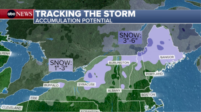
Saturday morning, snow continues across Upstate New York and into northern New England. An additional widespread 1 to 3 inches of snow can be expected from northwest New York to Maine, with some localized areas possibly getting over 3 inches of snow.
Heavier snow and severe weather
The next storm will be a stronger, cross-country storm that has been impacting the Pacific Northwest and northern Rockies since Friday and will sweep into the northern Rockies and Plains Saturday and the Midwest later Saturday into Sunday.
Winter storm warnings stretch from the Idaho Panhandle to the Upper Peninsula of Michigan, with some flight agencies cancelling flights ahead of this major winter storm.
Blizzard Warnings have also been issued for parts of South Dakota and southwest Minnesota for snowfall of more than a foot and strong winds up to 60 mph possible, with the National Weather Service warning that travel will likely become impossible late Saturday and Sunday.
By Sunday morning, snow stretches from South Dakota and Nebraska into the Great Lakes.
On the southern side of the powerful system, a line of severe storms will develop from Michigan down to Texas Sunday afternoon into the night.
An “Enhanced” risk (Level 3/5) has already been issued for parts of the Midwest on Sunday, from Indianapolis to just north of Memphis. Widespread damaging wind gusts will be the main threat although a few tornadoes will be possible along with large hail.
Chicago could go from thunderstorms on Sunday night to snow and whiteout conditions on Monday.
On Monday, the major storm will continue to move east. There will still be snow and wind across the Great Lakes and rounds of heavy rain and strong winds moving into the Northeast.
More severe weather will continue across the East Coast on Monday late afternoon into the evening from the Florida Panhandle up to Pennsylvania.
An “Enhanced” risk (level 3 of 5) has been issued for parts of the Carolinas, Virginia, Maryland and southern Pennsylvania. This includes Columbia, South Carolina; Raleigh, North Carolina; Richmond, Virginia; Washington, D.C; Baltimore, Maryland; and Harrisburg, Pennsylvania.
The main threat will be damaging winds, some large hail and a few tornadoes.
By the time this storm passes through, a widespread 3 to 6 inches of snow will be likely from Montana to the northern fringes of Upstate New York. The heaviest snow is expected from northeast South Dakota to the Upper Peninsula of Michigan, where 10 to 20 inches of snow will be possible, as well as gusty winds that could cause blowing snow and reduced visibility.
Copyright © 2026, ABC Audio. All rights reserved.